TOURIST SPOT
Address:徳島県三好市西祖谷山村善徳162-2
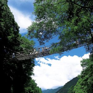
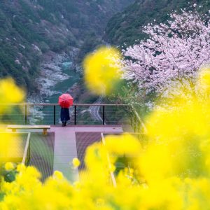
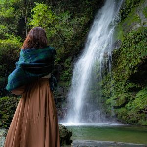
◆ Nationally Designated Important Tangible Folk Cultural Property ◆In the remote Iya Valley lies the Kazurabashi Bridge, said to hold the sorrowful tale of the defeated Heike clan. Woven from hardy shirokuchi kazura vines weighing about six tons, the bridge stretches 45 meters long, two meters wide, and hangs 14 meters above the river. Once the only way to cross these deep gorges, nowadays it is completely rebuilt every three years.The Iya area, nestled in the steep mountains of Shikoku, is said to have been a hidden refuge for the Heike clan after their defeat at the Battle of Yashima. Because access to the area remained difficult until modern times, the lifestyle and customs of medieval Japan have been remarkably well preserved here.Counted among Japan’s “Three Unusual Bridges,” Kazurabashi’s origins are surrounded by legend. Some say it was built by the fleeing Heike warriors so that it could be easily cut down to prevent pursuit; others believe the great Buddhist monk Kobo Daishi built it to help local villagers cross the river safely.Spanning the Iya River, the Kazurabashi Bridge has been designated a National Important Tangible Folk Cultural Property. Made by weaving vines gathered from the mountains in the severe cold of winter, the bridge gives visitors a thrilling experience—between the swaying motion and the open gaps in the planks through which one can see the ravine far below.The elegant form of the bridge, supported by ancient trees on both banks and reflecting in the clear stream of the Iya River, evokes the way of life of the ancestors who once lived here. It harmonizes beautifully with the natural surroundings and continues to captivate countless visitors with its unique charm.◆ Kazurabashi Night Illumination ◆The bridge is illuminated daily from 19:00 to 21:30 (Note: crossing the bridge is not permitted during this time). The illuminated bridge standing against the dark night is truly magical.◆ The Heike Legend’s “Biwa Waterfall” ◆Just about 50 meters to the left after crossing the bridge, you’ll find the Biwa Waterfall, featuring a 40-meter cascade.
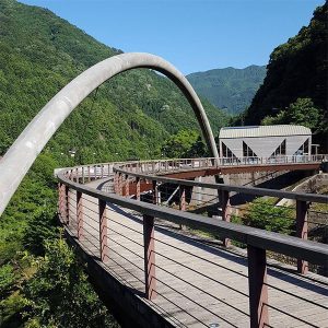
Address:徳島県三好市山城町重実~上名
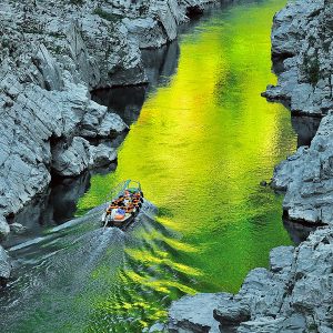
The Oboke Gorge has unusual geological strata, including a rudaceous schist formation designated as a natural monument. The Yoshino River has cut through the Shikoku Mountains over the ages, eroding crystalline schist into winding gorges with myriad shapes and forms, which almost look like marble statues. With fantastic reflections of cherry blossoms in spring and full autumn color in season, the river is host to a number of boating activities, from relaxing cruise down the calm part of the river, to an exciting rafting trip down the rapids. Koboke lies 3km downstream of Oboke and its scale is a little modest than Oboke, but is still beautiful and fascinating because of the rare shaped rock and its beauty of sandstone.
Address:徳島県三好市池田町松尾~西祖谷山村
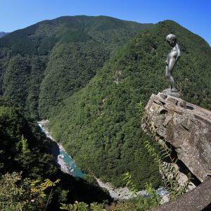
One of the highest accessible points in Iya Valley, the sheer cliffs of this gorge were carved by generations of the Iya River's flow. This majestic valley is known as "Hi no Ji Valley" for its resemblance to the Japanese letter "hi". The valley spans 20 kilometers, offering views of brilliant fresh green in spring and a spread of fiery foliage in autumn. Experience a dizzying beauty as you gaze down at the emerald current of the Iya River, winding along the mountain curves.As a symbol of innocent courage, a statue of a peeing boy was constructed at the edge of the nearby precipice, the most perilous spot in Iya Valley. In the old days, it's said the local children would stand on this cliff and urinate into the ravine to show their bravado.
Address:徳島県三好市山城町西宇1520
Phone:0883-84-1211
【Experience: Oboke Gorge Pleasure Cruise】 Marvel at the ever-changing beauty of curious rock formations and clear streams, shaped over 100 million years. A leisurely cruise through the Oboke and Koboke gorges lets you soak in the grandeur of untouched nature.From the boat gliding gently along the emerald-green Yoshino River, you’ll have close-up views of towering cliffs, trees swaying in the river breeze, and the sparkling flow of water. Don’t miss the chance to experience the dynamic natural beauty of this remarkable gorge.※ Cruise duration: approx. 30 minutes. Boarding and disembarking at the same location.【Dining: Oboke Gorge Mannaka Restaurant】 Set in a spectacular location overlooking the Yoshino River, this restaurant offers local cuisine made with fresh regional ingredients, all while enjoying breathtaking views of the gorge.Favorites include salt-grilled river fish, Iya soba noodles, and the original local specialty “Hidar Ramen.” After your boat cruise, savor the flavors of the region while gazing at the gorge’s seasonal beauty.【Souvenirs】 The on-site shop features a wide variety of regional specialties, including sake from Tokushima, locally grown tea, and sweets handmade at local confectioneries. You’ll also find carefully selected specialties from across Shikoku—perfect keepsakes to remember your trip.【Stay: Oboke Gorge Mannaka Onsen Inn】 Just a 3-minute walk from the boat landing, this tranquil hot spring inn is surrounded by nature. Relax in the soothing waters of its high-quality hot spring, unwind from the hustle and bustle of daily life, and enjoy a truly restful stay.

Address:徳島県三好市山城町平野
Phone:0883-86-3077
Shiozuka Plateau is at the 1,043m altitude and stretches out over both Tokushima and ehime prefectures in 100 hectares (250 acres) area. In autumn, the field turns into the shining silver with the Japanese pampas grass and on a fine day you can see as far as the Seto Inland Sea and even the Sanyo way. You will sometimes see the sea of clouds in the early morning of summer and it is breathtakingly beautiful.
Address:徳島県三好市山城町重実100−1
This is a scenic spot where you can get a panoramic view of the beautiful nature of Koboke. You can enjoy the majestic scenery of the rocks of Koboke Gorge, the beautiful emerald green Yoshino River, and the lush mountains that surround it. Located just 5 minutes from National Route 32, it is easily accessible and is the perfect place to stop by during a drive or sightseeing. You can also see trains and rafting, making it a recommended photo spot.
Address:徳島県三好市西祖谷山村尾井ノ内379
Phone:0883-76-8585
Address:徳島県三好市西祖谷山村善徳
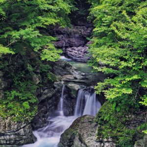
The legend holds that fleeting Heike warriors played their biwa, a Japanese lute, by this waterfall feeling nostalgic for their old city, Kyoto and comforted each other. The elegant name for this watefall with the height of 50 meters was originated from this legend.*If you walk further about 50m, there is a walkroad. Waling down stone stairs to the riverside, you can play there.
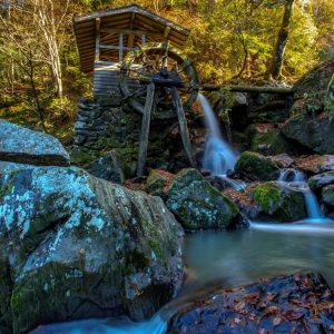
Address:徳島県三好市山城町頼広
Mountain stream of River Kurokawa formed ravine, giant rocks and boulders since ancient times. It is renowned spot for viewing fireflies in early summer and enjoying Japanese maple trees in autumn. It is a tranquil place with an old watermill nearby. It is also said that Chosogabe and his army rested here for a spell when they were on the way to conquer whole of Shikoku. The best time to view the autumn leaves is around mid-November.
Address:徳島県三好市山城町仏子
Tobinosu Canyon is formed of upheaved coulee, sharpened schist eroded by fierce current of Shirakawa river, which is a tributary stream of Yoshino River. Its variation of rocks and autumn colours reflected in the crystal clear river are such in harmony and are spectacular as like a grandeur natural park.
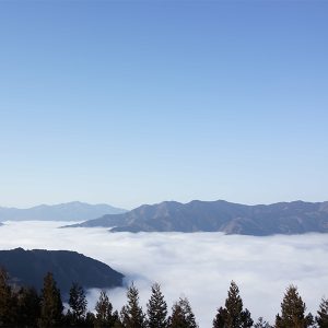
Address:徳島県三好市西祖谷山村上吾橋237
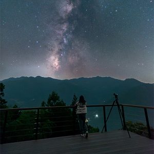
From the observation deck you can see Oboke, Yoshino River and Kochi direction, enjoy the viewing and shooting of the sea of clouds.
Address:徳島県三好市池田町松尾黒川
Mt.Ryugatake rises to the south-western slop side of Mt.Kaina-Yama and midstream of Matsuo river runs through. The sheer precipice is a few hundred meters in height and is over 2km breadth. The spectacular view is colored with fresh green vegetation in spring and with beautiful foliage in autumn. The precipice in sunset reflection is particularly beautiful.
Address:徳島県三好市山城町上名
Nokanoikeyama lies at 1,294 meters above sea level. There you will find thick habitat of Hon-Shakunage (non-hybrid rhododendron) in the concave marsh. Moss and originally the Northern plants are seen on the forest bed under rhododendron trees and those are regarded as academically valuable vegetations.
Address:徳島県三好市西祖谷山村田ノ内
Mt. Kunimi lies majestically between Iya Valley and Oboke Ravine. (1409 m high) It has a pnoramic view with 360-degree visibility. From Tsurugi Mountains to Ishizuchi Mountains, the panoramic scenery around Shikoku mountains, proves its reputation! Suitable time for climbing is from early April to late November. The most recommended time is November for its picturesque scenery. [Copied from Information Board at the starting point] * Approximately 1.9 km from the entrance parking to the summit (Around 50-minute walk)
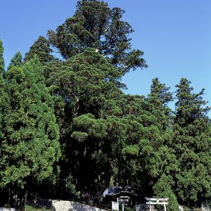
Address:徳島県三好市西祖谷山村上吾橋310
Also called as a cedar of Gosho shrine and it is a natural monument of Tokushima prefecture. The age of this cedar is supposed to be 1,100 years old with 45 meters in height and at 5 meters above the ground, 7 branches spreds out of this tree.
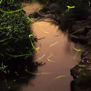
Address:徳島県三好市山城町頼広660
Many “Genji Hotaru” (Genji Firefly) flit around Kurokawadani in mid-June every year, where the “Kurokawadani firefly festival” takes place. It is popular to view the fireflies' glow during hot summer nights. (Hotaru inhabits only clean streams.) At festival, there are also fine displays of various crops & vegetables and bonsai, which are on sale along with buckwheat noodle , rice cake and etc.

Latest Information
© 2018 City of Miyoshi.