TOURIST SPOT・EXPERIENCE
Address:徳島県三好市西祖谷山村善徳162-2
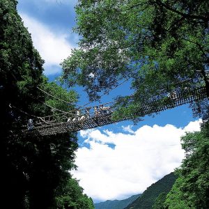
◆ 国指定重要有形民俗文化財 ◆平家一族の哀話を秘める、秘境“祖谷”にあるかずら橋。シラクチカズラ(重さ約6トン)で作られたもので、長さ45m・幅2m・水面上14m。 昔は深山渓谷地帯の唯一の交通施設であった。3年毎に架替えが行われる。急峻な四国山地に抱かれた祖谷地域は、屋島の合戦に敗れ逃れた平国盛と安徳帝の一行が、平家再興を願い土着したと伝わる隠田集落であり、近代まで外部との交通が隔絶されていたために、中世以来の生活様式や独特の風俗が原形に近い状態で残されている。この祖谷地域を流れる祖谷川に、国の重要有形民俗文化財に指定された祖谷のかずら橋が架かっている。 厳寒な冬の山野で採取したシラクチカズラを編み連ねて作られたこの橋は、橋床の隙間から谷底が見え、長さ45mの吊り橋の揺れと相まって渡る人に適度なスリルを味わわせる。日本三奇橋にも数えられるかずら橋の由来には諸説あり、平家の落人が追手から逃れるために切り落とせるように作ったとする説や四国を巡行された弘法大師が困っている村人の為に作ったという説などが伝えられている。両岸の古木に重みを託し、祖谷川の清流に影を映した悠然たるかずら橋の姿は、遠い昔の祖先の暮らしを想い抱かせるとともに、自然と調和した美しい景観を生み出し、その強烈な個性は多くの観光客の琴線を刺激し続けている。◎祖谷のかずら橋ライトアップ 毎日19:00〜21:30の間かずら橋をライトアップします(渡橋はできません) 闇夜の中に照らされた「かずら橋」が幻想的です。◎平家伝説の残る「琵琶の滝」がすぐそばです。 祖谷のかずら橋を渡ってすぐに左に50mくらい行くと、落差約40mの滝が現れます。
Address:徳島県三好市山城町重実~上名
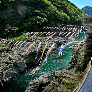
The Oboke Gorge has unusual geological strata, including a rudaceous schist formation designated as a natural monument. The Yoshino River has cut through the Shikoku Mountains over the ages, eroding crystalline schist into winding gorges with myriad shapes and forms, which almost look like marble statues. With fantastic reflections of cherry blossoms in spring and full autumn color in season, the river is host to a number of boating activities, from relaxing cruise down the calm part of the river, to an exciting rafting trip down the rapids. Koboke lies 3km downstream of Oboke and its scale is a little modest than Oboke, but is still beautiful and fascinating because of the rare shaped rock and its beauty of sandstone.
Address:徳島県三好市池田町松尾~西祖谷山村
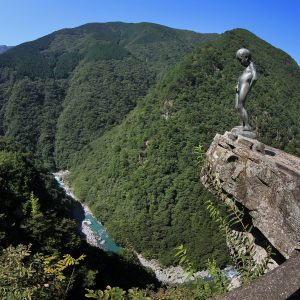
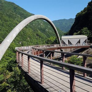
One of the highest accessible points in Iya Valley, the sheer cliffs of this gorge were carved by generations of the Iya River's flow. This majestic valley is known as "Hi no Ji Valley" for its resemblance to the Japanese letter "hi". The valley spans 20 kilometers, offering views of brilliant fresh green in spring and a spread of fiery foliage in autumn. Experience a dizzying beauty as you gaze down at the emerald current of the Iya River, winding along the mountain curves.As a symbol of innocent courage, a statue of a peeing boy was constructed at the edge of the nearby precipice, the most perilous spot in Iya Valley. In the old days, it's said the local children would stand on this cliff and urinate into the ravine to show their bravado.
Address:徳島県三好市山城町西宇1520
Phone:0883-84-1211
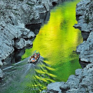
Take a 30 minute ride along the pure green waters of the Yoshino River, enjoying nature's handiwork on both sides. Scenic views of the gorge's crystalline schist resemble marble sculptures, and the fresh green of the surrounding forests in summer, the fiery foliage in autumn, or winter's shimmering frosts, make for a spectacular sight in any season.

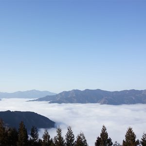
Address:徳島県三好市山城町平野
Phone:0883-86-3077
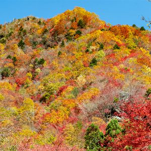
Shiozuka Plateau is at the 1,043m altitude and stretches out over both Tokushima and ehime prefectures in 100 hectares (250 acres) area. In autumn, the field turns into the shining silver with the Japanese pampas grass and on a fine day you can see as far as the Seto Inland Sea and even the Sanyo way. You will sometimes see the sea of clouds in the early morning of summer and it is breathtakingly beautiful.
Address:徳島県三好市西祖谷山村尾井ノ内379
Phone:0883-76-8585
Address:徳島県三好市山城町西宇1468-1
Phone:0883-84-1117
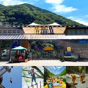
This is a complex sightseeing facility located at the entrance to Oboke and Iya. An Iya soba noodle shop whose house was rebuilt from an old folk house, an authentic Tokushima Ramen restaurant, a gift shop, an outdoor shop, and a convenience store are on business. The facilities is also complete with features such as a downward slope that leads straight to the river, an observation platform and wooden deck, BBQ house, and dog park. It's also the starting point of the Rafting Koboke Course.
Address:徳島県三好市池田町松尾黒川
Mt.Ryugatake rises to the south-western slop side of Mt.Kaina-Yama and midstream of Matsuo river runs through. The sheer precipice is a few hundred meters in height and is over 2km breadth. The spectacular view is colored with fresh green vegetation in spring and with beautiful foliage in autumn. The precipice in sunset reflection is particularly beautiful.
Address:徳島県三好市山城町上名
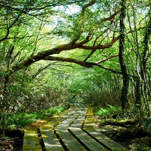
Nokanoikeyama lies at 1,294 meters above sea level. There you will find thick habitat of Hon-Shakunage (non-hybrid rhododendron) in the concave marsh. Moss and originally the Northern plants are seen on the forest bed under rhododendron trees and those are regarded as academically valuable vegetations.
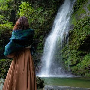
Address:徳島県三好市西祖谷山村善徳
The legend holds that fleeting Heike warriors played their biwa, a Japanese lute, by this waterfall feeling nostalgic for their old city, Kyoto and comforted each other. The elegant name for this watefall with the height of 50 meters was originated from this legend.*If you walk further about 50m, there is a walkroad. Waling down stone stairs to the riverside, you can play there.
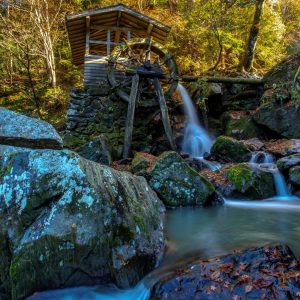
Address:徳島県三好市山城町頼広
Mountain stream of River Kurokawa formed ravine, giant rocks and boulders since ancient times. It is renowned spot for viewing fireflies in early summer and enjoying Japanese maple trees in autumn. It is a tranquil place with an old watermill nearby. It is also said that Chosogabe and his army rested here for a spell when they were on the way to conquer whole of Shikoku. The best time to view the autumn leaves is around mid-November.
Address:徳島県三好市西祖谷山村田ノ内
Mt. Kunimi lies majestically between Iya Valley and Oboke Ravine. (1409 m high) It has a pnoramic view with 360-degree visibility. From Tsurugi Mountains to Ishizuchi Mountains, the panoramic scenery around Shikoku mountains, proves its reputation! Suitable time for climbing is from early April to late November. The most recommended time is November for its picturesque scenery. [Copied from Information Board at the starting point] * Approximately 1.9 km from the entrance parking to the summit (Around 50-minute walk)
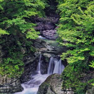
Address:徳島県三好市山城町仏子
Tobinosu Canyon is formed of upheaved coulee, sharpened schist eroded by fierce current of Shirakawa river, which is a tributary stream of Yoshino River. Its variation of rocks and autumn colours reflected in the crystal clear river are such in harmony and are spectacular as like a grandeur natural park.
Address:徳島県三好市山城町重実100−1
This is a scenic spot where you can get a panoramic view of the beautiful nature of Koboke. You can enjoy the majestic scenery of the rocks of Koboke Gorge, the beautiful emerald green Yoshino River, and the lush mountains that surround it. Located just 5 minutes from National Route 32, it is easily accessible and is the perfect place to stop by during a drive or sightseeing. You can also see trains and rafting, making it a recommended photo spot.
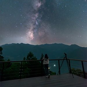
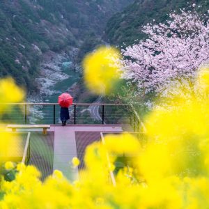
Address:徳島県三好市西祖谷山村上吾橋237
From the observation deck you can see Oboke, Yoshino River and Kochi direction, enjoy the viewing and shooting of the sea of clouds.
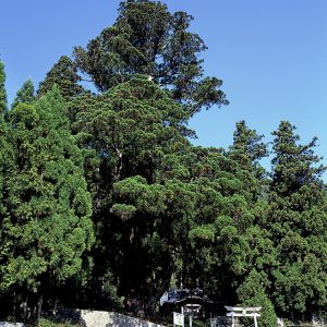
Address:徳島県三好市西祖谷山村上吾橋310
Also called as a cedar of Gosho shrine and it is a natural monument of Tokushima prefecture. The age of this cedar is supposed to be 1,100 years old with 45 meters in height and at 5 meters above the ground, 7 branches spreds out of this tree.
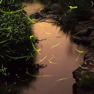
Address:徳島県三好市山城町頼広660
Many “Genji Hotaru” (Genji Firefly) flit around Kurokawadani in mid-June every year, where the “Kurokawadani firefly festival” takes place. It is popular to view the fireflies' glow during hot summer nights. (Hotaru inhabits only clean streams.) At festival, there are also fine displays of various crops & vegetables and bonsai, which are on sale along with buckwheat noodle , rice cake and etc.

Latest Information
© 2018 City of Miyoshi.